Résumé
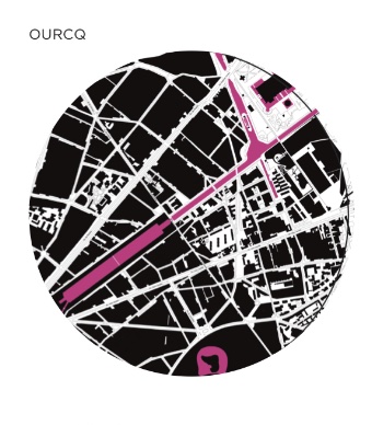
Cet article se propose d’explorer la relation entre habitabilité et accessibilité urbaine en temps de Covid-19. Si l’habitabilité urbaine est constituée par une série d’ajustements et de réajustements que chaque ville fait dans le temps pour permettre le ‘vivre ensemble’ en période ordinaire mais aussi extra-ordinaire, nous faisons l’hypothèse que la notion d’accessibilité est opératoire pour comprendre comment la ville se redessine à l’ère de la Covid-19. Nous avons mené une enquête cartographique avec des étudiants de l’École Nationale Supérieure d’Architecture de Paris La Villette, qui visait à comprendre comment une idée d’accessibilité urbaine pouvait ressurgir à partir de la transcription spatiale des restrictions mises en œuvre par le gouvernement. Pour amorcer cette démonstration, nous avons effectué une "opération cartographique” en partant de la méthode de Giambattista Nolli, inventée pour cartographier la ville de Rome en 1748.
Abstract
This article explores the interaction between habitability and urban accessibility in Covid-19 time. If urban habitability is constituted by a series of adjustments and readjustments that any city makes over time to allow for ’coexistence’ in both ordinary and extra-ordinary times, we hypothesize that the notion of accessibility is operative to understand how the city redesigns itself in the Covid-19 era. We conducted a cartographic investigation with students from the École Nationale Supérieure d’Architecture de Paris La Villette, which aimed to understand how an idea of urban accessibility might re-emerge from the spatial transcription of government-imposed restrictions. To begin this demonstration, we carried out a ’cartographic operation’ based on Giambattista Nolli’s method, invented to map the city of Rome in 1748.

